Precipitation is part of most people’s lives, but what are the four main types of precipitation, and how do they form?
When we look at the weather forecast, besides temperature the weather type is the most important.
Precipitation isn’t limited to rain, there are four main categories. Each category forms at different temperatures and with the help of different processes.
Let’s dive into the wondering world of precipitation types
The four main types of precipitation: rain, snow, hail and sleet all form by one of these two processes: the process of coalescence, Bergeron process. There are only two types of clouds that produce precipitation: cumulonimbus and nimbostratus. The temperatures that the precipitation encounters underway is an important factor in deciding the type of precipitation.
What is Precipitation?
Precipitation can occur in multiple forms, but when we look at the concept of precipitation, we will need to look broader.
The concept of precipitation isn’t limited to the weather. It can also be found in chemics, for example.
But when speaking about the weather, precipitation is the product of condensing water vapor that falls from the clouds due to gravity.
Based on the temperature in the clouds, precipitation forms differently and based on the temperatures that the precipitation encounters on its way down, it can take different forms.
The Types of Clouds

Since the clouds are the origin of nearly every drop of rain, a flake of snow and stone of hail, it’s important to take a look at the different types of clouds.
There are a lot of cloud types, but essentially there are only two that produce significant precipitation. The other clouds (mostly the stratus type) produce some drizzle at best.
Both of the cloud types that produce precipitation are vertical clouds. That means that they are generally pretty high, resulting in the potential growth of the precipitation drops or flakes.
The Precipitation-Producing Clouds
The nimbostratus cloud type is one of these clouds that produces precipitation. It is mostly found at fronts (more on that later).
The appearance of nimbostratus clouds is a lot away from stratus clouds, hence the name. The skies are mostly bland grey when encountering these clouds. Precipitation intensities are mainly light to moderate.
The second type of cloud is the cumulonimbus cloud. This type, also known as the thunderstorm cloud, produces generally heavier rain in the form of showers and thunderstorms.
From far away these clouds can look like cauliflowers in the sky. But when under the cloud, it doesn’t differ that much from the nimbostratus type.
The two types of clouds that produce significant precipitation are nimbostratus and cumulonimbus clouds, both vertical cloud types.
Weather Fronts
A front is an imaginary line between two types of air. There are three main types of fronts:
- Warm Front
- Cold Front
- Occlusion Front
When there is warmer air behind the front, it is called a warm front. These fronts generally come with nimbostratus clouds and thus light to moderate, but steady precipitation.
The cold front is the opposite, so when there is colder air behind the front. Instead of nimbostratus clouds, this front is accompanied by cumulonimbus clouds.
That results in showers with moderate to heavy precipitation and a chance of thunder.
When a cold front catches up to a warm front, it is called an occlusion front. The first part is built-up of nimbostratus clouds, while the backside of the front consists of cumulonimbus clouds.
What Are The Four Main Types Of Precipitation?
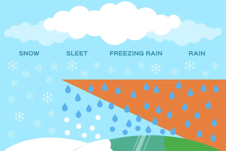
There are four main types of precipitation, with some being more obscure than others. There are also other types that can be a combination of two of the main types.
These four types are the most occurring and distinct types:
- Rain
- Snow
- Hail
- Sleet
Each of these types is formed differently, with different processes and at different temperatures. We will take a deeper look into each of these 4 types of precipitation.
1. Rain
Probably the most known precipitation type is rain. It isn’t only the most known type, but also the most common if you look at the whole world.
Except for the highest peaks, driest deserts and the North- and the South Pole, all places on earth receive some sort of rain amount each year.
There are two ways in which rain can form, and rain can form inside nimbostratus as well as cumulonimbus clouds. The first one is the process of coalescence.
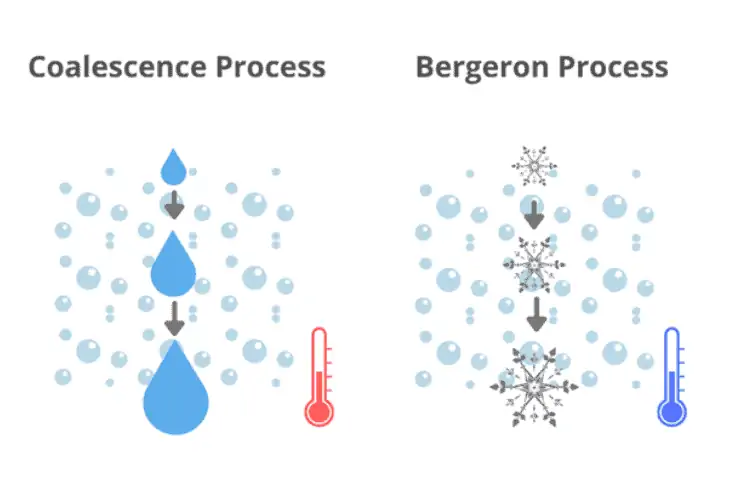
In essence, this is the process of water droplets merging together into bigger drops. It occurs in the clouds as long as the temperature is above 32°F (0°C).
So mostly on not-so-cold days, and in the lower layers of the clouds. When the drop is heavy enough, it falls down to the earth.
If the temperature is below freezing, the Bergeron process occurs. In this case, small water droplets that are still in liquid form freeze into ice crystals.
Just like with the process of coalescence, if the particle is heavy enough, it falls down. The Bergeron effect initially forms snow. But when it reaches warmer air layers lower in the thermosphere it can melt into raindrops.
The two processes to form rain are the coalescence process (above freezing) and the Bergeron process (below freezing). If the drops get heavy enough, they fall to the ground.
2. Snow
The second most common precipitation type is snow. Snow forms with the help of the Bergeron process, like described in the previous section about rain.
But when the ice crystal is heavy enough to fall to the ground, temperatures must remain below freezing in most layers of the thermosphere, to result in the snow on the ground.
Snowflakes are tiny ice crystals, most of the time they group together in packs, which are perceived as snowflakes. If the temperature of the ground is below 32°F (0°C), snowflakes can remain to lay on the ground.
A misconception about snow is that it needs to be below freezing for precipitation to fall as snow. This isn’t entirely true. Even if the temperatures at eye-height aren’t below freezing, if the air above is cold enough, precipitation can fall as snow.
But the chances of a snow blanket are small, this is called melting snow. The reason for this is that snowflakes do not melt immediately if they encounter warmer air.
Snow can form either in nimbostratus or cumulonimbus clouds, as long as temperatures are low enough.
Snowflakes are formed inside clouds where temperatures are below freezing with the help of the Bergeron process.
3. Hail
Hail only forms in the cumulonimbus type of cloud. Inside these clouds, there can be strong circulating convection currents.
These currents transport particles through the clouds. When small raindrops get transported up, they freeze. When they eventually again go below the freezing level, other small droplets attach to this small hailstone.
When the hailstone gets transported back up, these droplets freeze and the cycle starts again.
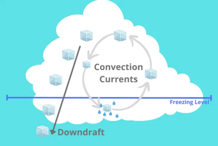
Based on how strong the circulation is, hailstones can get as big as an egg. When the weight of the hailstone is too high, it gets sent to the ground via the downdraft.
Although hail looks like a winter phenomenon, it’s actually more common in the summer.
When the temperatures and moisture levels are high, thunderstorms can form with a strong circulating current, resulting in hail, because the tops of these storms reach far above the freezing level.
Hailstones are only formed inside cumulonimbus clouds, because of the strong circulation convection currents.
4. Sleet and Freezing Rain
When it is freezing at ground level, but there is a layer of warmer air up high, snowflakes melt to raindrops in this warm layer. Based on how big the cold layer is under this warm layer, sleet or freezing rain will occur.
If the layer is big enough, the rain will have time to freeze again, not into snowflakes, but into small ice cubes. They are not to be confused with hail. Sleet particles are generally much smaller and form totally different to hail.
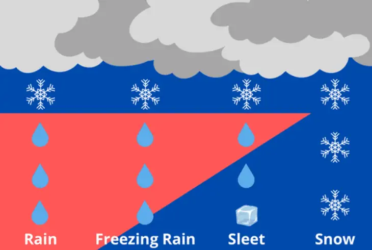
When the layer of cold air is not so thick, the rain will cool, but will not freeze. But in this cooled state, the rain will freeze immediately when it reaches the cold surface. This freezing rain can cause very dangerous situations.
When it has been cold for some while and a warm front moves in, these types can occur. Because warm air moves over the cold air, the precipitation will first fall as snow. Then it will transform to sleet and later to freezing rain, to eventually turn into general rain.
Sleet and freezing rain occur if there is a warm layer of air between two cold ones. Depending on the size of this layer, the precipitation falls as sleet or freezing rain.
There are two cloud types that lay at the base for every type of precipitation: Cumulonimbus and Nimbostratus. If temperatures are above freezing, the coalescence process occurs, otherwise, the Bergeron process occurs.
Based on the temperatures the precipitation encounters underway, it falls on the ground as snow, rain or sleet. Hail is a story on its own.
Read Next: What Happens if a Car Gets Struck by Lightning?
Final Thoughts
But there are many more different types of precipitation besides rain. What are the four main types of precipitation?
The main ones are snow, hail and sleet. Although the precipitation is different, two clouds: nimbostratus and cumulonimbus and two processes: the Bergeron process and the process of coalescence lay at the base of all types.